The Atlantic Ocean, a dynamic and complex body of water, plays a pivotal role in global climate regulation. Its intricate current systems, particularly the Atlantic Meridional Overturning Circulation (AMOC), act as a colossal conveyor belt, distributing heat, nutrients, and carbon throughout the planet. Understanding and monitoring these currents is not merely an academic exercise; it is a critical endeavor for predicting weather patterns, assessing climate change impacts, and safeguarding marine ecosystems. Recent advancements in technology and scientific methodologies have revolutionized the way researchers observe and analyze these oceanic leviathans, offering unprecedented insights into their behavior and future trajectories.
The Atlantic Ocean’s currents are not static entities; they are subject to a multitude of forces, both natural and anthropogenic. Changes in their strength, speed, or trajectory can have far-reaching consequences, echoing across continents and impacting human populations. Therefore, a robust and continuous monitoring program is not a luxury but a fundamental requirement for informed decision-making.
The AMOC: A Climate Regulator
The Atlantic Meridional Overturning Circulation, often referred to as the AMOC, is a prime example of a critical ocean current system. This deep-ocean circulation pattern, driven by differences in water temperature and salinity, transports warm surface waters poleward and returns colder, denser waters equatorward. Think of it as the planet’s internal heating and cooling system, regulating climate through its vast heat transport. Disruptions to this system, such as a slowdown or collapse, could lead to significant shifts in regional climates, including colder winters in Europe and altered rainfall patterns in vital agricultural regions. Monitoring its strength and stability is akin to keeping a vital organ under constant observation.
Impact on Weather and Climate Patterns
The influence of Atlantic currents extends directly to weather patterns. The Gulf Stream, a powerful component of the AMOC, is well-known for its role in moderating the climate of Western Europe, making it significantly warmer than other regions at similar latitudes. Further north, the North Atlantic Oscillation (NAO), a large-scale atmospheric pressure fluctuation, is intrinsically linked to ocean heat transport. Understanding the intricate dance between these oceanic and atmospheric systems is crucial for improving seasonal weather forecasts and predicting extreme weather events. If the ocean currents are the conductor, the atmosphere is the orchestra, and slight changes in the conductor’s tempo can lead to dramatic shifts in the performance.
Marine Ecosystem Dynamics
Ocean currents are not just physical forces; they are also biological arteries, transporting nutrients, plankton, and larvae across vast distances. This movement directly influences marine food webs and the distribution of marine species. Changes in current patterns can disrupt these delicate ecosystems, leading to shifts in fish populations, coral bleaching events, and the spread of invasive species. For fisheries management and marine conservation efforts, understanding these oceanic highways is paramount. Imagine a network of roads, and consider the impact if essential routes were suddenly altered or blocked.
Recent advancements in Atlantic Ocean current monitoring technology have significantly enhanced our understanding of ocean dynamics and climate patterns. For a deeper insight into the implications of these technologies, you can read the article on oceanographic innovations at Freaky Science. This article explores various methods and tools used in current monitoring, shedding light on their importance in predicting weather changes and understanding marine ecosystems.
Technological Leaps in Data Acquisition
The ability to monitor Atlantic Ocean currents has been dramatically enhanced by the advent of innovative technologies. Gone are the days when observations were limited to sporadic ship-based measurements. Today, a sophisticated array of instruments provides a continuous, high-resolution stream of data, painting a much clearer picture of these complex systems.
Autonomous Underwater Vehicles (AUVs)
Autonomous Underwater Vehicles, or AUVs, have become invaluable tools in oceanography. These robotic submarines can be programmed to follow specific paths, collecting data on temperature, salinity, current velocity, and even biological parameters over extended periods without human intervention. Gliders, a specific type of AUV, are particularly efficient, using buoyancy changes to propel themselves through the water column, conserving energy and allowing for long deployments. They are like silent, tireless sentinels, constantly patrolling the oceanic depths and reporting their findings.
Satellite Altimetry and Gravimetry
From the vantage point of space, satellites provide a synoptic view of the ocean surface. Satellite altimeters precisely measure sea surface height, which, when combined with geoid models, allows scientists to deduce ocean current speeds and directions. Furthermore, satellite gravimetry missions measure tiny variations in Earth’s gravity field, providing insights into changes in ocean mass and deep-ocean circulation. These satellites offer an unparalleled bird’s-eye perspective, revealing the broad strokes of ocean circulation patterns that would be impossible to discern from localized observations.
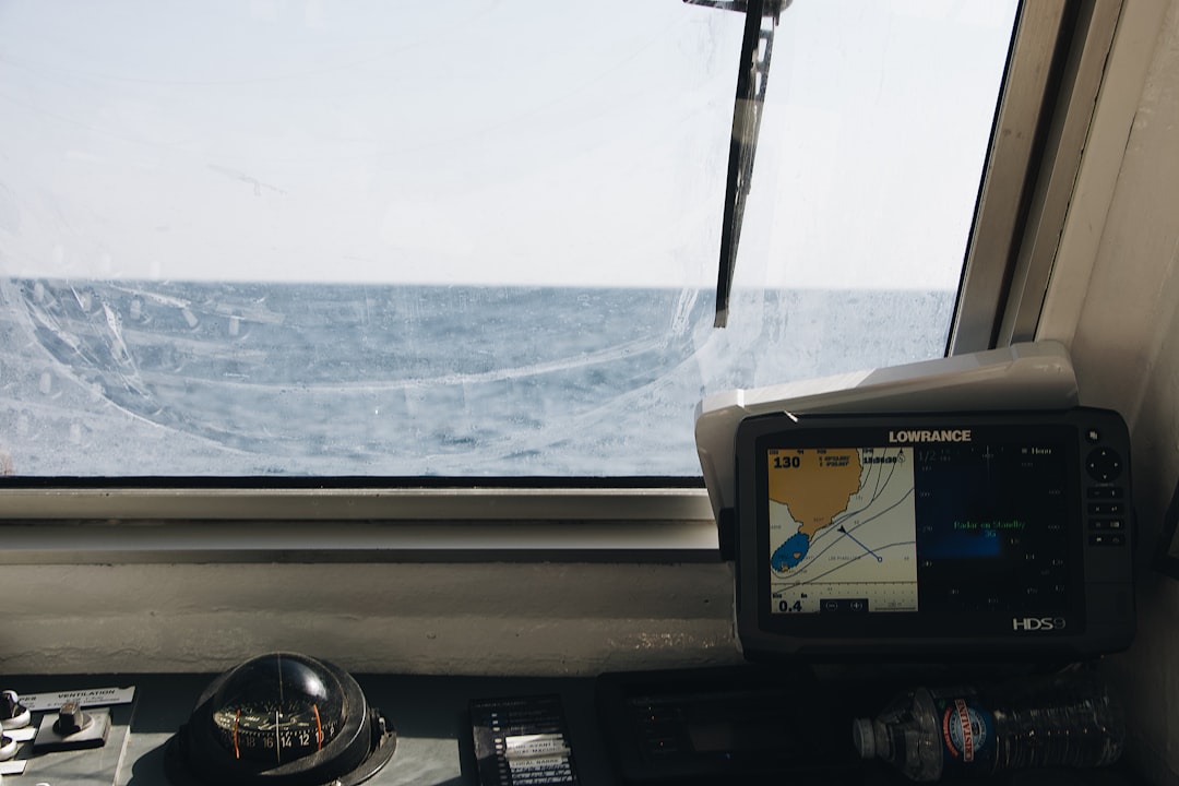
Moored Array Systems
While AUVs and satellites offer broad coverage, moored arrays provide continuous, long-term observations at specific locations. These systems consist of instrumented cables anchored to the seafloor, extending upwards through the water column. They house a variety of sensors, including current meters, temperature and salinity probes, and acoustic Doppler current profilers (ADCPs). The RAPID Array, for instance, is a prominent example, spanning the Atlantic at 26.5°N and providing crucial data on the AMOC’s strength. These moored arrays are like the fixed pulse points, consistently monitoring the rhythm of the ocean at critical junctures.
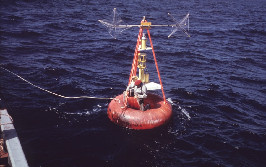
Drifters and Floats
Surface drifters and subsurface floats are relatively simple yet highly effective tools for tracking ocean currents. Drifters are deployed at the surface and are carried by surface currents, while profiling floats, such as those used in the Argo program, drift at predetermined depths and periodically ascend to the surface to transmit data. These devices provide Lagrangean observations, effectively following water parcels and revealing their trajectories, offering a personal narrative of individual water movements as they journey across the ocean.
Advanced Data Analysis and Modeling Techniques
Collecting vast amounts of oceanographic data is only half the battle. The true power lies in the ability to process, analyze, and interpret this information to extract meaningful insights and forecast future behavior. This has been made possible by significant advancements in computational power and sophisticated modeling techniques.
Numerical Ocean Models
Numerical ocean models are sophisticated computer simulations that represent the physical processes governing ocean circulation. These models integrate equations of fluid dynamics, thermodynamics, and atmospheric forcing to simulate ocean currents, temperature, and salinity distributions. As observational data becomes more abundant and accurate, these models can be continuously refined and validated, leading to increasingly realistic and predictive simulations. They are the crystal balls of oceanography, allowing scientists to peer into the past, present, and potential future of ocean dynamics.
Data Assimilation for Improved Predictions
Data assimilation is a crucial technique that combines observational data with numerical model outputs to produce the most accurate representation of the ocean state. This process essentially “corrects” model predictions with real-world observations, reducing uncertainties and improving the reliability of forecasts. Think of it as a quality control mechanism, ensuring that the model’s narrative aligns with the observed reality. This iterative process allows for continuous learning and adaptation, making models more robust and reliable over time.
Artificial Intelligence and Machine Learning Applications
The sheer volume and complexity of oceanographic data present an ideal scenario for the application of artificial intelligence (AI) and machine learning (ML) techniques. AI algorithms can identify subtle patterns and relationships within datasets that might be missed by human analysis, leading to new discoveries and hypotheses. Machine learning can be used for tasks such as anomaly detection, predicting current variability, and even optimizing sensor placement. As the data stream continues to grow, AI and ML will become indispensable navigators through this ocean of information, extracting valuable insights that were previously hidden beneath the waves.
Emerging Frontiers and Future Outlook
The field of Atlantic Ocean current monitoring is continuously evolving, with exciting new technologies and research avenues on the horizon. The ongoing quest for a more complete and accurate understanding of these critical systems drives innovation and collaboration across disciplines.
Real-Time, High-Resolution Monitoring Networks
The trend is towards denser, more integrated monitoring networks that can provide real-time, high-resolution data across vast swathes of the Atlantic. This involves deploying more autonomous platforms, enhancing satellite capabilities, and developing new sensor technologies that can measure an even wider array of geophysical and biochemical parameters. Imagine a nervous system for the entire Atlantic, providing instant feedback on its state and allowing for much quicker responses to changes.
Integration of Biological and Chemical Parameters
Beyond physical oceanography, there is a growing recognition of the need to integrate biological and chemical parameters into monitoring efforts. Understanding how changes in currents affect nutrient transport, primary productivity, and the distribution of marine life is essential for a holistic assessment of ocean health. For example, tracking the movement of carbon and oxygen within the ocean’s intricate circulation systems provides vital insights into the ocean’s role as a carbon sink and its capacity to support marine ecosystems. This integrated approach allows scientists to move beyond simply observing the ocean’s mechanics to understanding its very breath and lifeblood.
International Collaboration and Data Sharing
The Atlantic Ocean knows no political boundaries, and neither should its monitoring. International collaboration is paramount to the success of these large-scale endeavors. Sharing data, expertise, and resources among nations and research institutions is crucial for building a global, comprehensive picture of Atlantic current dynamics. Programs like the Global Ocean Observing System (GOOS) exemplify this commitment to collaborative data collection and dissemination, ensuring that the insights gained from monitoring are accessible to researchers and policymakers worldwide. In essence, it’s a global effort to decipher a global puzzle.
Bridging the Gap Between Science and Policy
Ultimately, the advancements in Atlantic Ocean current monitoring must translate into actionable policy decisions. This requires effective communication between scientists and policymakers, ensuring that the complex scientific findings are understood and incorporated into climate adaptation strategies, resource management plans, and international agreements. The more we understand about the ocean’s currents, the better equipped we will be to navigate the challenges coming our way due to a changing climate. The ocean’s whisper needs to be heard and acted upon, guiding humanity towards a more sustainable future.
FAQs
What is Atlantic Ocean current monitoring technology?
Atlantic Ocean current monitoring technology refers to the tools and systems used to observe, measure, and analyze the movement of ocean currents in the Atlantic Ocean. These technologies help scientists understand current patterns, speed, temperature, and other oceanographic data.
Why is monitoring Atlantic Ocean currents important?
Monitoring Atlantic Ocean currents is crucial for climate research, weather forecasting, marine navigation, and ecosystem management. Currents influence global climate systems, affect marine biodiversity, and impact coastal communities.
What types of technology are used to monitor Atlantic Ocean currents?
Common technologies include satellite remote sensing, underwater gliders, drifting buoys, acoustic Doppler current profilers (ADCPs), and moored instruments. These devices collect data on current velocity, direction, temperature, and salinity.
How do satellites contribute to monitoring ocean currents?
Satellites provide large-scale, real-time data by measuring sea surface height, temperature, and color. This information helps track surface current patterns and changes over time across the Atlantic Ocean.
What challenges exist in monitoring Atlantic Ocean currents?
Challenges include the vast size and depth of the ocean, harsh weather conditions, equipment maintenance, and data transmission difficulties. Additionally, integrating data from various sources to create accurate models remains complex.