Geological forces are the powerful natural processes that shape the Earth’s surface over time. These forces, driven by the dynamic nature of the planet, include tectonic movements, erosion, volcanic activity, and glacial movements.
Understanding these forces is essential for comprehending the intricate tapestry of the Earth’s geography and the evolution of its features. The study of geological forces reveals a complex interplay between various elements of the Earth’s system. These forces are not only responsible for creating stunning landscapes but also for shaping ecosystems and influencing human activities.
As scientists delve deeper into the mechanisms behind these geological processes, they uncover the profound impact that these forces have had on the planet’s history and its future. The following sections will explore specific geological forces and their contributions to the formation and transformation of the Earth’s surface.
Key Takeaways
- Plate tectonics play a crucial role in the formation of mountain ranges, shaping the Earth’s surface over millions of years.
- Erosion significantly impacts landforms, creating diverse and unique landscapes such as canyons and valleys.
- Volcanic activity contributes to the formation of new land and influences the overall landscape through lava flows and ash deposits.
- Glaciers have played a key role in shaping the US map, carving out valleys and leaving behind distinctive features like the Great Lakes.
- Earthquakes can have a profound impact on the terrain, causing sudden shifts and changes in the landscape.
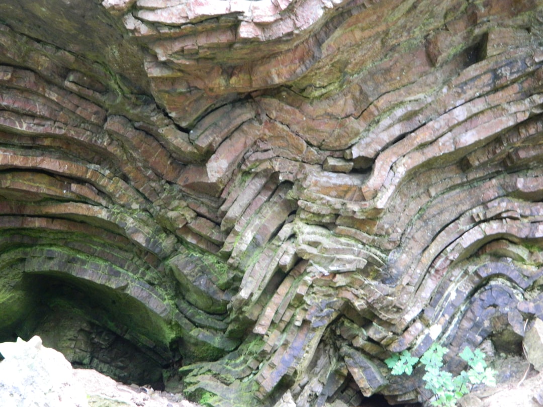
Plate Tectonics and the Formation of Mountain Ranges
Plate tectonics is a fundamental concept in geology that explains how the Earth’s lithosphere is divided into several large plates that float on the semi-fluid asthenosphere beneath them. The movement of these tectonic plates is responsible for many geological phenomena, including the formation of mountain ranges. When two tectonic plates collide, they can push against each other, causing the Earth’s crust to buckle and fold, leading to the creation of majestic mountains.
This process is evident in regions such as the Himalayas, where the collision of the Indian and Eurasian plates has resulted in some of the highest peaks on Earth. The formation of mountain ranges through plate tectonics is not a rapid process; rather, it occurs over millions of years. As tectonic plates continue to shift, mountains can rise, erode, and even be reformed.
The Appalachian Mountains in North America, for instance, were formed through a series of tectonic events that began over 480 million years ago. Their current form is a testament to the long history of geological activity that has shaped them. Understanding plate tectonics provides insight into not only mountain formation but also the broader dynamics of Earth’s geology.
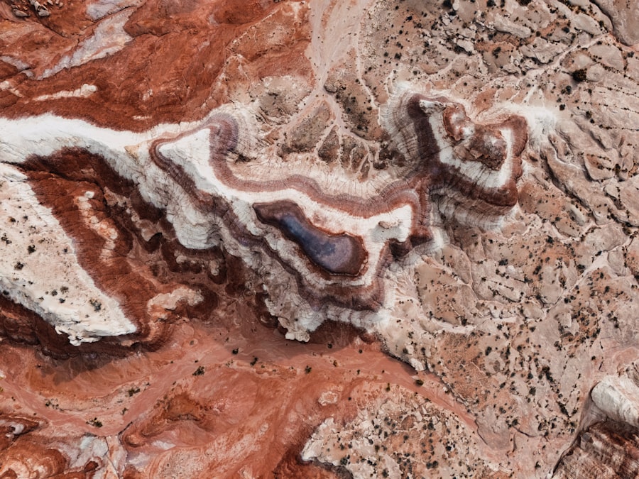
The Impact of Erosion on Landforms
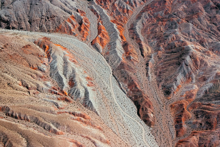
Erosion is a powerful geological force that gradually wears away rocks and soil, reshaping landscapes over time. This process can occur through various agents, including water, wind, ice, and gravity. Erosion plays a significant role in sculpting landforms by transporting sediments from one location to another, leading to the creation of valleys, canyons, and other geological features.
For example, rivers can carve deep gorges into rock formations as they flow, illustrating how persistent erosion can dramatically alter a landscape. The impact of erosion is not limited to landforms; it also affects ecosystems and human activities. As soil is eroded away, it can lead to decreased agricultural productivity and increased sedimentation in waterways, which can harm aquatic habitats.
Additionally, erosion can expose underlying rock layers, revealing geological history and providing valuable information for scientists studying Earth’s past. The balance between erosion and deposition is crucial for maintaining healthy landscapes and ecosystems.
Volcanic Activity and its Influence on the Landscape
| Volcano Name | Location | Volcanic Explosivity Index (VEI) | Impact on Landscape |
|---|---|---|---|
| Mount St. Helens | Washington, USA | 5 | Created a large crater and changed the surrounding landscape |
| Krakatoa | Indonesia | 6 | Caused a massive eruption and altered the coastline |
| Mauna Loa | Hawaii, USA | 4 | Created new land through lava flows |
Volcanic activity is another significant geological force that shapes the Earth’s surface. When magma from beneath the Earth’s crust escapes to the surface, it can create volcanic landforms such as mountains, islands, and plateaus. The eruption of a volcano can dramatically alter the surrounding landscape in a matter of moments, depositing ash and lava that solidify into new rock formations.
The Hawaiian Islands are a prime example of how volcanic activity can create landmasses over time through repeated eruptions. In addition to creating new landforms, volcanic activity also influences existing landscapes through processes such as pyroclastic flows and lahars. These volcanic hazards can reshape terrain and pose risks to nearby communities.
Moreover, volcanic eruptions can have far-reaching effects on climate and ecosystems by releasing gases and ash into the atmosphere. Understanding volcanic activity is essential for assessing risks and managing landscapes affected by these powerful geological forces.
The Role of Glaciers in Shaping the US Map
Glaciers are massive bodies of ice that move slowly across land, carving out valleys and shaping landscapes as they advance and retreat. During periods of glaciation, glaciers have played a crucial role in shaping the geography of regions such as North America. The last Ice Age left a profound mark on the United States, with glaciers sculpting features like the Great Lakes and creating U-shaped valleys in mountainous areas.
As glaciers move, they erode rock and soil, transporting sediments that can be deposited elsewhere when the ice melts. This process has contributed to the formation of moraines, drumlins, and other glacial landforms that dot the landscape. The impact of glaciers extends beyond physical geography; they also influence ecosystems by creating unique habitats and affecting water availability in regions where they melt.
Understanding glacial processes is vital for comprehending both past climate changes and current environmental challenges.
Earthquakes and their Effects on the Terrain
Earthquakes are sudden releases of energy in the Earth’s crust that result from tectonic movements. These seismic events can have dramatic effects on the terrain, causing ground shaking that may lead to landslides, ground ruptures, and even tsunamis in coastal areas. The impact of an earthquake on a landscape can be immediate and devastating, reshaping landforms in seconds while also posing significant risks to human life and infrastructure.
The study of earthquakes provides valuable insights into tectonic activity and helps scientists understand fault lines and seismic zones. Regions like California are particularly prone to earthquakes due to their location along major fault lines such as the San Andreas Fault. By monitoring seismic activity and understanding its effects on terrain, researchers can develop better preparedness strategies for communities at risk from these geological forces.
The Formation of Valleys and Canyons
Valleys and canyons are striking landforms that result from various geological processes, including erosion by rivers and glacial activity. River valleys are typically formed through the continuous flow of water that carves out channels in the landscape over time. As rivers meander through terrain, they erode banks and deposit sediments downstream, creating fertile valleys that are often ideal for agriculture.
Canyons, on the other hand, are often formed through more intense erosion processes. The Grand Canyon in Arizona serves as a prime example of how persistent river erosion can create deep gorges over millions of years. The Colorado River has played a pivotal role in carving this iconic landscape, showcasing how geological forces work together to shape dramatic features on Earth’s surface.
Understanding how valleys and canyons form provides insight into both past geological events and current environmental conditions.
Coastal Processes and the Creation of Shorelines
Coastal processes are essential in shaping shorelines around the world. Waves, tides, and currents continuously interact with landmasses along coastlines, leading to erosion and deposition that create diverse coastal features such as beaches, cliffs, and estuaries. The dynamic nature of coastal environments means that they are constantly changing due to both natural forces and human activities.
Erosion along coastlines can lead to significant changes in landforms over time. For instance, wave action can erode cliffs while depositing sand along beaches, creating a delicate balance between loss and gain.
Understanding these processes is vital for managing coastal areas effectively and mitigating risks associated with rising sea levels and climate change.
The Influence of Rivers and Streams on Geography
Rivers and streams are vital components of Earth’s hydrological cycle and play a significant role in shaping geography. They act as natural pathways for water flow while also serving as agents of erosion that sculpt landscapes over time. As rivers meander through terrain, they create floodplains, deltas, and other features that contribute to biodiversity and ecosystem health.
The influence of rivers extends beyond physical geography; they have historically served as critical resources for human civilization. Many cities have developed along riverbanks due to access to fresh water for drinking, agriculture, and transportation. Additionally, rivers often act as natural boundaries between regions or countries.
Understanding how rivers shape geography provides insight into both natural processes and human interactions with these vital waterways.
The Formation of Natural Resources through Geological Forces
Geological forces are instrumental in forming natural resources that are essential for human society. Processes such as sedimentation, metamorphism, and volcanic activity contribute to the creation of valuable minerals, fossil fuels, and other resources found within the Earth’s crust. For instance, coal deposits form from ancient plant material subjected to heat and pressure over millions of years.
The extraction of these natural resources has significant implications for economies worldwide but also raises environmental concerns regarding sustainability and habitat destruction. As societies continue to rely on these resources for energy production and industrial processes, understanding their geological origins becomes increasingly important for responsible management practices. Balancing resource extraction with environmental stewardship is crucial for ensuring a sustainable future.
Human Interaction with Geological Forces and its Impact on the US Map
Human interaction with geological forces has profoundly influenced the development of landscapes across the United States. Urbanization, agriculture, mining, and infrastructure development have all altered natural processes while reshaping geographical features. For example, damming rivers has transformed waterways into reservoirs but has also disrupted natural sediment transport processes essential for maintaining healthy ecosystems.
Moreover, human activities often exacerbate geological hazards such as landslides or flooding by altering drainage patterns or destabilizing slopes through construction practices. As communities continue to expand into geologically active areas or regions prone to natural disasters like earthquakes or hurricanes, understanding these interactions becomes critical for disaster preparedness and risk mitigation strategies. In conclusion, geological forces are fundamental drivers behind the formation and transformation of landscapes across the globe.
From plate tectonics creating mountain ranges to rivers sculpting valleys and human activities reshaping environments, these forces interact in complex ways that define our planet’s geography. By studying these processes comprehensively, society can better appreciate Earth’s dynamic nature while fostering sustainable practices that respect both natural systems and human needs.
In exploring the geological processes that have shaped the map of the United States, it’s fascinating to consider the dynamic forces of plate tectonics, erosion, and volcanic activity that have sculpted the diverse landscapes we see today. For a deeper dive into the science behind these natural phenomena, you might find the article on Freaky Science particularly enlightening. It delves into the intricate details of how these geological processes have not only influenced the physical geography of the U.S. but also its ecological and cultural development. To read more about these fascinating topics, check out this related article on Freaky Science.
WATCH THIS! The Earth is Trying to Swallow North America: The Unstoppable Geological Disaster
FAQs
What are geological processes?
Geological processes are natural processes that shape the Earth’s surface and interior, including processes such as erosion, plate tectonics, volcanic activity, and sedimentation.
How do geological processes shape the US map?
Geological processes such as tectonic plate movement, erosion, and volcanic activity have shaped the physical features of the US map, including mountain ranges, river valleys, and coastal plains.
What are some specific examples of geological processes shaping the US map?
Examples of geological processes shaping the US map include the formation of the Rocky Mountains through tectonic plate movement, the erosion of the Grand Canyon by the Colorado River, and the volcanic activity that formed the Hawaiian Islands.
How do geological processes impact the environment and human activity in the US?
Geological processes can impact the environment and human activity in the US by influencing the distribution of natural resources, creating hazards such as earthquakes and landslides, and shaping the landscape for activities such as agriculture and urban development.
What role do geological processes play in the formation of natural resources in the US?
Geological processes play a crucial role in the formation of natural resources in the US, including the creation of mineral deposits, fossil fuels, and groundwater resources through processes such as sedimentation, volcanic activity, and tectonic forces.