Geological hazards represent a significant threat to human life, infrastructure, and the environment. These natural phenomena arise from the dynamic processes of the Earth, including tectonic movements, volcanic activity, and erosion. As populations grow and urban areas expand, the risks associated with these hazards become increasingly pronounced.
Understanding geological hazards is crucial for developing effective strategies to mitigate their impacts and enhance community resilience. The study of geological hazards encompasses a wide range of events, from earthquakes and volcanic eruptions to landslides and tsunamis. Each type of hazard presents unique challenges and requires tailored approaches for risk assessment and management.
As climate change continues to alter weather patterns and geological processes, the frequency and intensity of these hazards may also change, necessitating a proactive stance in preparedness and response efforts.
Key Takeaways
- Geological hazards pose significant risks to communities in North America and require proactive measures for mitigation and preparedness.
- Earthquakes, volcanic activity, landslides, tsunamis, and sinkholes are some of the key geological hazards that pose threats to North America.
- Understanding the threat of earthquakes is crucial for preparedness and mitigation efforts, as they can cause widespread destruction and loss of life.
- Volcanic activity presents risks and impacts such as lava flows, ashfall, and pyroclastic flows, which can have devastating effects on nearby communities.
- Identifying vulnerable areas for landslides and rockfalls is essential for implementing measures to reduce the risks and protect communities from these geological hazards.
Types of Geological Hazards in North America
North America is home to a diverse array of geological hazards, each influenced by the continent’s unique geological features and climatic conditions. Earthquakes are perhaps the most well-known geological hazard, particularly in regions along the Pacific Ring of Fire, where tectonic plates converge. The San Andreas Fault in California serves as a prime example of this risk, with its history of significant seismic activity posing a constant threat to nearby communities.
In addition to earthquakes, volcanic activity is another critical concern in North America. The Cascade Range in the Pacific Northwest is dotted with active volcanoes, such as Mount St. Helens and Mount Rainier, which have the potential to erupt with devastating consequences.
Furthermore, landslides and rockfalls are prevalent in mountainous regions, particularly after heavy rainfall or seismic events. These hazards can lead to significant property damage and loss of life, especially in areas where development encroaches on unstable slopes.
Earthquakes: Understanding the Threat
Earthquakes are sudden and violent shaking of the ground caused by the movement of tectonic plates beneath the Earth’s surface. The energy released during an earthquake can result in widespread destruction, particularly in densely populated urban areas. The severity of an earthquake is measured on the Richter scale, with higher magnitudes indicating more powerful tremors.
In North America, regions such as California, Alaska, and parts of the Pacific Northwest are particularly vulnerable to seismic activity. The impacts of earthquakes extend beyond immediate physical damage. They can trigger secondary hazards such as tsunamis, landslides, and fires, compounding the overall risk to communities.
For instance, the 1906 San Francisco earthquake not only devastated the city but also ignited fires that destroyed large portions of it. Understanding the potential for these secondary effects is essential for effective disaster planning and response.
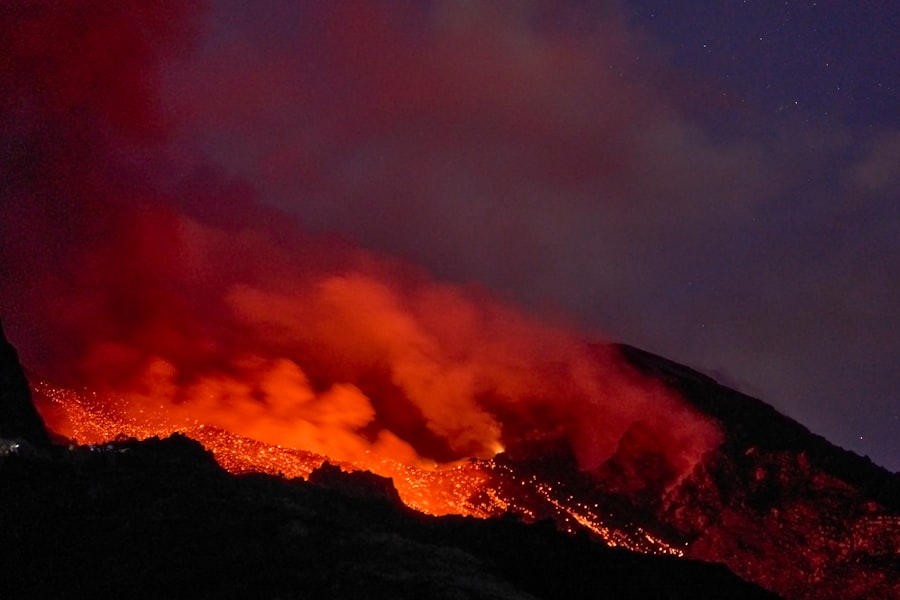
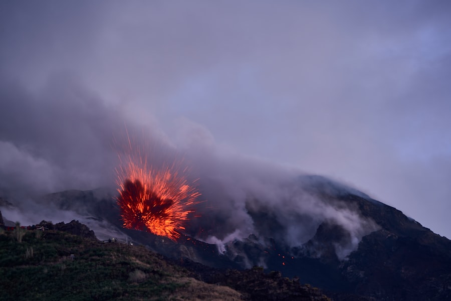
Volcanic Activity: Risks and Impacts
| Volcanic Activity | Risks | Impacts |
|---|---|---|
| Pyroclastic flows | High risk to nearby communities | Destruction of infrastructure and loss of life |
| Lahars | Can travel long distances | Damage to buildings and agriculture |
| Ash fall | Respiratory problems | Disruption of transportation and utilities |
| Lava flows | Slow-moving but destructive | Destruction of property and infrastructure |
Volcanic activity poses a unique set of risks that can have far-reaching consequences for both human populations and the environment. Eruptions can release ash clouds that disrupt air travel, contaminate water supplies, and pose health risks to those living nearby. The potential for pyroclastic flows—fast-moving currents of hot gas and volcanic matter—adds another layer of danger, as these flows can obliterate everything in their path.
In North America, the potential for volcanic eruptions is particularly pronounced in areas like Yellowstone National Park, which sits atop a supervolcano. While large-scale eruptions are rare, the consequences could be catastrophic, affecting air quality and climate on a global scale. Monitoring volcanic activity through advanced technology and research is crucial for early warning systems that can help mitigate risks associated with eruptions.
Landslides and Rockfalls: Identifying Vulnerable Areas
Landslides and rockfalls are geological hazards that occur when soil or rock becomes unstable and moves down a slope. These events can be triggered by various factors, including heavy rainfall, earthquakes, or human activities such as construction and mining. Identifying areas at risk for landslides is essential for effective land-use planning and disaster preparedness.
Regions with steep terrain or loose soil are particularly susceptible to landslides. In North America, the Appalachian Mountains and the Sierra Nevada are examples of areas where landslides frequently occur. Communities located near these vulnerable zones must implement monitoring systems to detect early signs of instability and develop evacuation plans to protect residents in case of an event.
Tsunamis: Coastal Risks and Preparedness
Tsunamis are large ocean waves typically caused by underwater earthquakes or volcanic eruptions. When these waves reach coastal areas, they can cause catastrophic flooding and destruction. The Pacific coast of North America is especially at risk due to its proximity to tectonic plate boundaries where seismic activity is common.
Preparedness for tsunamis involves establishing early warning systems that can alert coastal communities to impending danger. Education plays a vital role in ensuring that residents understand evacuation routes and safety protocols. Historical events, such as the 2004 Indian Ocean tsunami, serve as stark reminders of the devastating impact these natural disasters can have on coastal populations.
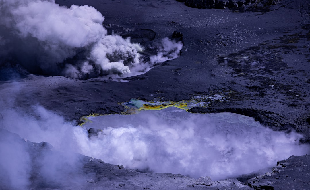
Sinkholes: Recognizing the Danger
Sinkholes are depressions or holes in the ground caused by the collapse of surface material into underground voids or cavities. They can occur suddenly and without warning, posing significant risks to infrastructure and human safety. Areas with limestone bedrock are particularly prone to sinkhole formation due to a process known as karst topography.
In North America, states like Florida are well-known for their susceptibility to sinkholes due to extensive limestone formations beneath the surface. Recognizing the signs of potential sinkhole activity—such as cracks in pavement or sudden depressions in yards—is crucial for residents living in affected areas. Local governments must also implement monitoring systems to assess ground stability and provide guidance on construction practices that minimize sinkhole risks.
Understanding the Impact of Climate Change on Geological Hazards
Climate change is increasingly recognized as a significant factor influencing geological hazards. Rising global temperatures can lead to more intense rainfall events, increasing the likelihood of landslides and flooding. Additionally, melting glaciers can destabilize slopes in mountainous regions, further heightening the risk of geological events.
The interplay between climate change and geological hazards necessitates a comprehensive approach to risk assessment and management. Communities must adapt their infrastructure to withstand changing weather patterns while also considering how these changes may affect geological stability. By integrating climate science into hazard planning, communities can better prepare for future challenges posed by both natural disasters and climate-related events.
Risk Assessment and Management Strategies
Effective risk assessment is essential for understanding vulnerabilities associated with geological hazards. This process involves identifying high-risk areas, evaluating potential impacts, and developing strategies to mitigate those risks. Geographic Information Systems (GIS) technology plays a crucial role in mapping hazard-prone regions and analyzing data related to past events.
Management strategies may include implementing land-use regulations that restrict development in high-risk areas or investing in infrastructure improvements designed to withstand geological events. Public education campaigns can also raise awareness about preparedness measures individuals can take to protect themselves during emergencies.
The Role of Government and Communities in Mitigating Geological Hazards
Governments at all levels play a critical role in mitigating geological hazards through policy development, funding for research, and emergency response planning. Federal agencies such as FEMA (Federal Emergency Management Agency) provide resources for disaster preparedness while also coordinating response efforts during emergencies. Community involvement is equally important in building resilience against geological hazards.
Local organizations can facilitate training programs that educate residents about risks specific to their area while also promoting community engagement in disaster preparedness initiatives. By fostering collaboration between government agencies and local communities, a more comprehensive approach to hazard mitigation can be achieved.
Building Resilience in the Face of Geological Hazards
In conclusion, geological hazards pose significant threats that require ongoing attention from both government entities and local communities. By understanding the various types of hazards present in North America—such as earthquakes, volcanic activity, landslides, tsunamis, and sinkholes—individuals can better prepare themselves for potential disasters. As climate change continues to influence geological processes, it becomes increasingly important for communities to adopt proactive measures that enhance resilience against these natural threats.
Through effective risk assessment, management strategies, and collaborative efforts between government agencies and local organizations, communities can work towards minimizing the impacts of geological hazards while safeguarding lives and property for future generations.
Geological hazards pose significant risks across the North American continent, with events such as earthquakes, volcanic eruptions, and landslides impacting both human populations and natural landscapes. Understanding these hazards is crucial for developing effective mitigation strategies and ensuring public safety. For a deeper insight into the various geological phenomena affecting North America, you can explore a related article on this topic by visiting Freaky Science. This resource provides valuable information on the science behind these natural events and their implications for the continent.
WATCH THIS! The Earth is Trying to Swallow North America: The Unstoppable Geological Disaster
FAQs
What are geological hazards?
Geological hazards are natural processes or phenomena that have the potential to cause harm or damage to human life, property, and the environment. These hazards include earthquakes, volcanic eruptions, landslides, tsunamis, and floods.
What are the major geological hazards on the North American continent?
The major geological hazards on the North American continent include earthquakes along the Pacific Ring of Fire, volcanic eruptions in the Cascade Range and Alaska, landslides in mountainous regions, tsunamis along the Pacific coast, and flooding in various areas.
How do geological hazards impact the North American continent?
Geological hazards can have significant impacts on the North American continent, including loss of life, destruction of infrastructure, economic disruption, and environmental damage. These hazards can also lead to long-term consequences such as displacement of communities and loss of biodiversity.
What measures are in place to mitigate geological hazards on the North American continent?
Various measures are in place to mitigate geological hazards on the North American continent, including building codes and regulations, early warning systems, hazard mapping, land-use planning, and public education and awareness campaigns. Additionally, ongoing research and monitoring help to better understand and prepare for these hazards.
How can individuals prepare for geological hazards on the North American continent?
Individuals can prepare for geological hazards by creating emergency plans, securing their homes and belongings, assembling emergency kits, staying informed about local hazards, and participating in community preparedness efforts. It is also important to have a basic understanding of the geological hazards in their area and how to respond in the event of an emergency.