
Plate boundaries are dynamic zones where tectonic plates interact, leading to various geological phenomena. These boundaries can be classified into three main types: convergent, divergent, and transform. Each type of boundary exhibits unique characteristics and behaviors, influencing the geological landscape and seismic activity of the regions they traverse.
Among these, transform boundaries, where plates slide past one another, are particularly notable for their potential to generate significant earthquakes. The San Andreas Fault in California serves as a prime example of a transform plate boundary, showcasing the complexities and dangers associated with such geological features. Understanding plate boundary transitions is crucial for comprehending the Earth’s geological processes.
These transitions not only shape the physical landscape but also pose risks to human settlements and infrastructure. As tectonic plates shift, they can create stress that is released in the form of earthquakes, making it essential for scientists and researchers to study these areas closely. The San Andreas Fault, with its rich history of seismic activity, provides valuable insights into the behavior of transform boundaries and the potential hazards they present.
Key Takeaways
- Plate boundaries are areas where tectonic plates meet and interact, leading to various geological activities.
- The San Andreas Fault is a well-known transform fault in California, with a history of significant seismic activity.
- The fault was formed by the movement of the Pacific and North American tectonic plates, causing ongoing tectonic activity in the region.
- The geographical impact of the fault includes the creation of valleys, mountains, and other landforms, as well as potential hazards for nearby communities.
- Historical earthquakes and ongoing seismic activity in the region highlight the need for monitoring, research, and preparedness efforts to mitigate potential risks.
Overview of the San Andreas Fault
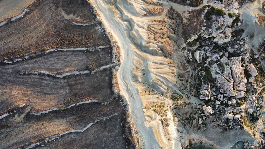
The San Andreas Fault is one of the most studied geological features in the world, stretching approximately 800 miles through California. It marks the boundary between the Pacific Plate and the North American Plate, making it a critical site for understanding tectonic movements. The fault runs from the Salton Sea in the south to Cape Mendocino in the north, traversing a diverse range of landscapes, including mountains, valleys, and urban areas.
Its significance extends beyond geology; it has become a symbol of California’s seismic risk and a focal point for earthquake preparedness efforts. This fault is not just a single crack in the Earth’s crust; it consists of multiple segments that behave differently under stress. Some sections are locked, accumulating strain over time, while others may slip more frequently, releasing energy in smaller earthquakes.
This complex behavior makes predicting seismic events challenging. The San Andreas Fault serves as a living laboratory for geologists and seismologists who seek to understand the mechanics of faulting and the implications for communities living in proximity to this active geological feature.
Formation and Tectonic Activity
The formation of the San Andreas Fault can be traced back millions of years to the tectonic processes that shaped California’s landscape. The Pacific Plate and North American Plate began to slide past each other due to the movement of the Earth’s lithosphere.
Over time, the continuous movement of these plates has led to significant geological changes, including the uplift of mountain ranges and the creation of valleys. Tectonic activity along the San Andreas Fault is characterized by episodic slip events, which can vary in magnitude and frequency. The fault experiences both slow slip events, which may not be felt at the surface, and sudden releases of energy that result in earthquakes.
This variability complicates efforts to predict when and where significant seismic events will occur. Researchers utilize advanced monitoring techniques, including GPS and seismographs, to study these movements and gain insights into the fault’s behavior over time.
Geographical Impact of the Fault
| Location | Impact |
|---|---|
| California | High seismic activity |
| Japan | Tsunamis and earthquakes |
| Turkey | Earthquakes and landslides |
The geographical impact of the San Andreas Fault is profound, influencing not only the physical landscape but also human settlement patterns. The fault’s path cuts through several major cities, including Los Angeles and San Francisco, making it a critical consideration for urban planning and infrastructure development. The topography along the fault line features a mix of rugged mountains and flat valleys, shaped by centuries of tectonic activity.
This diverse landscape attracts residents and tourists alike but also poses significant risks during seismic events. In addition to altering landforms, the San Andreas Fault has implications for water resources in California. The fault’s movement can affect groundwater flow and surface water systems, leading to changes in water availability for agriculture and urban use.
Understanding these geographical impacts is essential for effective resource management and disaster preparedness. As communities continue to grow along this fault line, awareness of its geographical significance becomes increasingly important for ensuring safety and sustainability.
Historical Earthquakes and Seismic Activity
The history of seismic activity along the San Andreas Fault is marked by several significant earthquakes that have had lasting impacts on California’s communities. One of the most notable events was the 1906 San Francisco earthquake, which registered a magnitude of 7.9 and caused widespread destruction throughout the city. This catastrophic event not only reshaped San Francisco but also raised awareness about earthquake preparedness and building codes in urban areas prone to seismic activity.
In addition to historical earthquakes, ongoing seismic activity along the fault continues to pose risks to residents. Smaller tremors are frequent, serving as reminders of the fault’s dynamic nature. Researchers have documented numerous significant earthquakes over the past century, each contributing to a growing body of knowledge about how faults behave under stress.
This historical context is vital for understanding potential future risks and developing strategies for mitigating their impact on communities.
Monitoring and Research Efforts

Monitoring efforts along the San Andreas Fault have advanced significantly over recent decades, driven by technological innovations and a growing understanding of seismic hazards. Scientists employ a variety of tools to track tectonic movements, including GPS stations that measure ground displacement with remarkable precision. These monitoring systems provide real-time data that can help predict potential earthquakes and inform emergency response plans.
Research initiatives focused on the San Andreas Fault have also expanded, involving collaborations between universities, government agencies, and international organizations.
By studying past seismic events and ongoing tectonic activity, researchers hope to develop more effective strategies for risk reduction and community resilience in earthquake-prone areas.
Potential Risks and Preparedness
The potential risks associated with living near the San Andreas Fault are significant, prompting ongoing discussions about preparedness measures for residents and local governments alike. Earthquakes can lead to devastating consequences, including loss of life, property damage, and disruption of essential services. As such, it is crucial for communities along the fault line to develop comprehensive emergency response plans that address these risks.
Preparedness efforts include public education campaigns aimed at raising awareness about earthquake safety practices. Residents are encouraged to create emergency kits, establish communication plans with family members, and participate in earthquake drills. Local governments also play a vital role by enforcing building codes designed to enhance structural resilience against seismic forces.
By fostering a culture of preparedness, communities can better equip themselves to respond effectively when an earthquake strikes.
Regional and Global Seismic Hazards
The San Andreas Fault is not only a local concern; it is part of a broader network of seismic hazards that extend across California and beyond. The interactions between various faults in the region can amplify seismic risks, leading to complex scenarios during major earthquakes. Additionally, researchers recognize that seismic activity along the San Andreas Fault can influence tectonic processes globally, highlighting its significance within the larger context of plate tectonics.
Understanding regional seismic hazards requires collaboration among scientists worldwide. By sharing data and research findings, experts can develop more comprehensive models that account for interconnected fault systems. This global perspective enhances preparedness efforts not only in California but also in other regions vulnerable to seismic activity.
As communities worldwide grapple with similar challenges posed by tectonic movements, lessons learned from studying the San Andreas Fault can inform strategies for risk reduction on a global scale.
Environmental and Ecological Effects
The environmental impact of the San Andreas Fault extends beyond human settlements; it also affects local ecosystems and wildlife habitats. The movement of tectonic plates can alter landscapes, creating new habitats while disrupting existing ones. For instance, changes in topography may influence water drainage patterns or soil composition, affecting plant growth and animal populations in affected areas.
Moreover, seismic activity can trigger secondary effects such as landslides or liquefaction during earthquakes, further impacting ecosystems. These environmental changes necessitate careful monitoring by ecologists who seek to understand how wildlife adapts to shifting landscapes caused by tectonic movements. By studying these ecological effects, researchers can better assess the long-term consequences of seismic activity on biodiversity and ecosystem health.
Future Predictions and Mitigation Strategies
Looking ahead, predictions regarding future seismic activity along the San Andreas Fault remain uncertain but critical for planning purposes. Scientists continue to refine models that estimate potential earthquake magnitudes and frequencies based on historical data and current monitoring efforts. While precise predictions are challenging due to the complex nature of fault behavior, ongoing research aims to improve understanding of how stress accumulates along different segments of the fault.
Mitigation strategies play a vital role in reducing risks associated with future earthquakes. These strategies encompass a range of approaches, from retrofitting buildings to withstand seismic forces to implementing land-use planning that minimizes development near high-risk areas. Public education campaigns also remain essential for fostering community resilience by equipping residents with knowledge about safety practices during an earthquake event.
Conclusion and Call to Action
In conclusion, the San Andreas Fault serves as a powerful reminder of nature’s forces and their potential impact on human life and infrastructure. As communities continue to grow along this active fault line, understanding its geological significance becomes increasingly important for ensuring safety and sustainability. Ongoing research efforts provide valuable insights into seismic activity while informing preparedness measures that can save lives during an earthquake.
A call to action is necessary for individuals, communities, and policymakers alike: prioritize earthquake preparedness through education initiatives, support research funding aimed at improving monitoring technologies, and advocate for resilient infrastructure development in vulnerable areas. By working together to address these challenges posed by tectonic movements along the San Andreas Fault—and similar geological features worldwide—society can enhance its ability to withstand future seismic events while safeguarding lives and livelihoods for generations to come.
The San Andreas Fault is a significant geological feature that marks the boundary between the Pacific and North American tectonic plates. This fault is a classic example of a transform boundary, where two plates slide past each other horizontally. An interesting related article on the topic can be found on Freaky Science, which delves into the complexities of plate boundary transitions and their implications for seismic activity. For more detailed insights, you can read the article by visiting this page. This resource provides a comprehensive overview of the geological processes at play and their potential impact on the surrounding regions.
WATCH THIS! The Earth is Trying to Swallow North America: The Unstoppable Geological Disaster
FAQs
What is a plate boundary transition?
A plate boundary transition refers to the area where two tectonic plates meet and interact. These transitions can be characterized by various geological features and processes, such as earthquakes, volcanic activity, and the formation of mountain ranges.
What is the San Andreas Fault?
The San Andreas Fault is a major geological fault in California, USA. It is a transform fault, where the Pacific Plate and the North American Plate are sliding past each other horizontally. The fault is known for its significant seismic activity and is a prominent feature of the tectonic boundary in the region.
How does the San Andreas Fault contribute to plate boundary transition?
The movement along the San Andreas Fault is a key factor in the plate boundary transition between the Pacific Plate and the North American Plate. The fault is responsible for the release of accumulated tectonic stress through earthquakes and the creation of new geological features.
What are the potential hazards associated with the San Andreas Fault?
The San Andreas Fault poses significant seismic hazards, as it has the potential to generate large earthquakes. These earthquakes can cause widespread damage to infrastructure, pose risks to human life, and disrupt regional economies. Additionally, the fault can also trigger tsunamis in certain areas.
How is the study of the San Andreas Fault important for understanding plate tectonics?
Studying the San Andreas Fault provides valuable insights into the dynamics of plate tectonics and the processes involved in plate boundary transitions. It helps scientists and researchers better understand the behavior of tectonic plates, the mechanisms of earthquakes, and the evolution of geological features over time.